The Calendar on the Wall

The Calendar on the Wall

The Calendar on the Wall

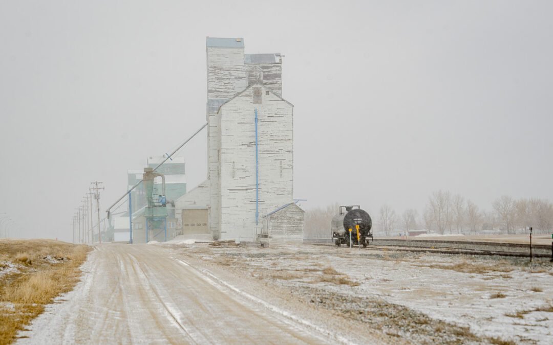
On September 21, 2020, I stopped at the corner of Highway 4 and 506, just north of Warner, Alberta, and looked east. The scene before me — a simple stretch of prairie, the kind you might drive past without much notice — carried more weight than most. I had stood here before in memory, not in person.

Back in the early 1960s, this very view appeared on an Alberta Wheat Pool calendar, either 1963 or 1964. I remember it clearly from my Grade 3–4 classroom in Masinasin, where Miss Miller pointed at the picture and told us proudly it was from our area. At the time, I had no way of knowing I would one day find myself standing in the same spot with a camera in hand, reconnecting with that fragment of my childhood.

The tie runs deeper than memory. My great-grandparents’ farm was at the first intersection east of here, and my mother spent summers there as a child. She would ride the Greyhound bus down from Lethbridge, getting dropped off right at the 506/4 junction. What was for her a gateway to summer on the farm later became, for me, a link between family history and the shared cultural memory of Alberta’s farming past.

The Alberta Wheat Pool calendars were once staples in prairie homes — free, practical, and filled with images of the land that shaped life across the West. They were more than decoration; they were markers of identity, showing the landscapes farmers knew by heart. Seeing this scene again in 2020, decades after first encountering it on a classroom wall, felt like collapsing time — past and present stitched together by prairie light.

Sometimes a photograph is just a record of a place. Other times, like this, it’s also a bridge between memory, heritage, and the stories we carry forward.


See this image and more in my ongoing Photo of the Day series at www.djtphotoart.ca

Sidebar: The Alberta Wheat Pool Calendar

For decades, the Alberta Wheat Pool calendar was a fixture in prairie homes, schools, and farm offices. Each year, the cooperative printed thousands of wall calendars featuring photographs of Alberta landscapes, elevators, and farms — often scenes recognizable to the very people who hung them.

The calendars weren’t just about keeping track of seeding, harvest, or community events. They were a way of reinforcing identity: farmers saw their land, their towns, and their lives reflected back at them. The Wheat Pool, as a farmer-owned cooperative, used these calendars to stay present in everyday life — quietly reminding members that they were part of something bigger than themselves.

For children in small-town schools, the pictures were sometimes their first taste of seeing their own communities “published.” And for adults, they became part of the rhythm of the year — flipped page by page, season by season, until another arrived in the mailbox.

Today, those old calendars have become nostalgic keepsakes, offering not just beautiful photographs but also a glimpse into the cooperative spirit that once defined prairie farming.

Warner-Elevators

Warner-Elevators

Historic wooden grain elevators in Warner, Alberta, disappear into a late spring snowstorm. A gravel road leads toward the vanishing structures, while an abandoned rail tanker car rests on the tracks, adding to the scene’s eerie atmosphere.

Warner Alberta’s Historic Grain Elevators: A Vanishing Prairie Icon in a Spring Snowstorm

The prairies hold stories of resilience, industry, and the passage of time. Nowhere is this more evident than in Warner, Alberta, where the last remaining wooden grain elevators stand as silent sentinels of a bygone era. My latest fine art photograph captures this historic scene during a late spring snowstorm—an image that speaks to both the endurance and fragility of the Canadian prairie landscape.

The Story Behind the Image

Snowstorms in late spring are not uncommon in Alberta, but they bring with them an eerie beauty. In this scene, Warner’s grain elevator row disappears into the storm, its towering structures fading into the whiteout. A gravel road leads the eye past these monolithic wooden elevators, once the lifeblood of the region’s agricultural economy. A lone rail tanker car sits on the tracks in the foreground, a quiet reminder of how transportation and trade once centered around these structures.

A Legacy of the Land: The History of Warner’s Grain Elevators

Warner, Alberta, once boasted at least seven wooden-cribbed grain elevators, built between 1913 and 1960 along the Canadian Pacific Railway line. These towering structures played a vital role in Alberta’s grain industry, serving farmers who relied on them to store and ship their harvests. Today, only four remain, standing as one of the last intact elevator rows in the province.

Key Moments in Warner’s Grain Elevator History:

  • 1913: The first elevator in the current row was built by the Alberta Farmers’ Co-operative Elevator Company.
  • 1939: The Ellison Milling & Elevator Company constructed one of the most historically significant elevators, maintaining much of its original design.
  • 1960s – Present: Many of the original elevators were demolished as the grain industry shifted towards centralized inland concrete terminals.
  • Today: The surviving elevators primarily handle mustard crops and serve as a rare reminder of Alberta’s agricultural heritage.

These grain elevators are more than just relics; they are cultural landmarks. Their gradual disappearance mirrors the transformation of farming and trade in Western Canada, making images like this a crucial part of preserving their history.

Why This Photograph Matters

As an artist, my mission is to capture the beauty of fleeting moments—those that define both place and time. This image of Warner’s grain elevators disappearing into a snowstorm is a testament to the delicate balance between nature and history. It is a tribute to the communities that built and relied on these structures, as well as a reminder of how quickly the familiar can fade away.

Limited Edition Prints Available

This fine art print is available in sizes ranging from 4×6 to 40×60 inches. Every piece is meticulously crafted in my studio using the latest archival inks and museum-quality paper, ensuring a lifespan of up to 200 years. Whether unframed, mounted with a 2-inch matte, or custom-framed, each print is a lasting investment in artistry and history.


Preserve a piece of Alberta’s history. Own a fine art print that tells the story of Warner’s vanishing grain elevators before they disappear forever.

Better late than never

Better late than never

Back at the start of the year, I said that as I went through all the images that I have taken over the years, I would post the best image for each day. However life has got in the way, and then we add the problems of the internet

The grain elevators at Warner from the west.

Red Wing blackbird from a slough near Warner

Same slough as the Red Winged Black bird

Female Red Winged Blackbird

old farm yards

If the walls could talk what would they say

what

For some reason this is one of the most viewed images on my stock image site.

Peace River Valley: A Lost Landscape remembered

Peace River Valley: A Lost Landscape remembered

View of the Peace River Valley from a Highway 29 lookout in 2006, showing lush terrain that is now submerged due to the Site C dam project.
 

Peace River Valley:
A Lost Landscape Remembered

Photo Date: July 22, 2006, 3:50 p.m. Camera: Nikon D70s with 80–200mm f/2.8 lens at 80mm Location: Highway 29 between Fort St. John and Hudson’s Hope, British Columbia This image was created on assignment for a newspaper article about the proposed Site C dam, long before construction began. The goal was to document the landscape — to show what was at risk of being submerged if the project moved forward. Photographed at 3:50 p.m. on July 22, 2006, using a Nikon D70s with an 80–200mm f/2.8 lens at 80mm, the image captures a moment in time that can no longer be replicated. In the foreground is a canola field nearing the end of its blooming stage, patches of yellow still scattered through the green. The middle ground holds a quiet farmyard, then a thick tree line that traces the edge of the Peace River valley. Beyond that, distant mountain ridges rise below long rows of white, fluffy clouds. This was part of a deliberate effort to record what would be lost — not just in terms of land, but of lived experience, heritage, and natural beauty. That entire valley — the farmland, trees, and historic terrain — is now submerged beneath the Site C reservoir. The location is part of a stretch of Highway 29 that I’ve always rated as one of the top three drives in the world. The other two: Highway 6 between Waterton and Pincher Creek, and State Route 20 through the North Cascades in northern Washington. This drive along the Peace River offered The photo is from the Peace River Rest Area, abou 29 km from Fort St John and giving a expansive view of the valley. Today, with the Site C dam complete, the geography has changed forever. This photograph remains one of the few intentional efforts I made simply to preserve the truth of a place before it disappeared.
1972 AMC Javelin

1972 AMC Javelin

A 1972 AMC Javelin parked on a street in Lethbridge, Alberta during Street Wheelers Weekend in July 2025. Classic muscle car with bold styling and deep paint color.

Street Legends: 1972 AMC Javelin at Street Wheelers Weekend

There’s something about a classic muscle car that stops people in their tracks — and this 1972 AMC Javelin was no exception. Spotted on the streets of Lethbridge, Alberta during the July 2025 Street Wheelers Weekend, this bold, fastback-styled beast turned heads as crowds filed past.

The Javelin isn’t as common a name as Mustang or Camaro, but ask any muscle car fan and they’ll tell you — this was AMC’s shot at taking on the big boys. With its aggressive lines, distinctive front end, and deep rumble, it carried every bit of the attitude the muscle car era was built on.

What caught my attention wasn’t just the car itself — it was the way people reacted to it. Kids barely old enough to know what it was stood slack-jawed while their parents traded stories about the ones they used to own, race, or chase down backroads. It was proof that classic car culture isn’t just nostalgia — it’s a living, breathing thing that still brings people together.

Street Wheelers Weekend has always been one of those events where the streets become the showgrounds. No velvet ropes, no display stands — just steel, chrome, and stories on wheels. And on this stretch of pavement, the 1972 AMC Javelin held court.

For more moments like this and a gallery full of automotive attitude, swing by www.djtphotoart.ca.

The Fascinating History of the Easom Place in Alberta

The Fascinating History of the Easom Place in Alberta

Photograph of Easom Place, a weathered three-storey wooden prairie home built in 1908, located east of Milk River, Alberta, with the Sweetgrass Hills visible in the cloudy background.

Over 1,000 image licenses and sales. Countless online appearances. One structure that continues to captivate the imagination of prairie travelers and photo collectors alike. The image you see above—taken along Alberta’s Secondary Highway 501—has officially surpassed the 1,000 mark in sales and licensing. Today, we’re celebrating that milestone and sharing the remarkable story behind this iconic image of Easom Place.

The Myth of the Barn:
Easom Place Uncovered

Most who drive past this weathered wooden building in Southern Alberta assume it’s a barn. The truth? It never was.

Easom Place, built in 1908, was originally a three-story family home. Located just 15 km east of Milk River on present-day Secondary Highway 501, the structure lies in an area once called Sleepy Hollow. Though its wooden form suggests “barn,” it never housed livestock — only stories.

After its early residents left, Easom Place was sold to a neighbor who later repurposed it into a granary. But its stone foundation remains as strong as it was more than a century ago — a quiet testament to prairie resilience.