
Peace River Valley:
A Lost Landscape Remembered
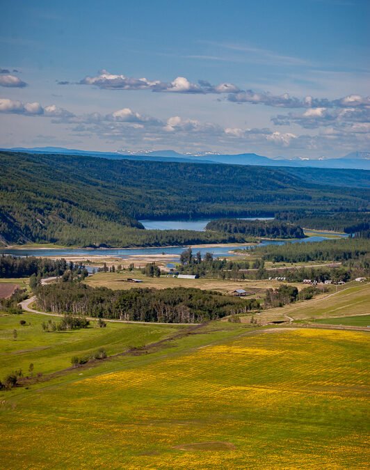
Photo Date: July 22, 2006, 3:50 p.m.
Camera: Nikon D70s with 80–200mm f/2.8 lens at 80mm
Location: Highway 29 between Fort St. John and Hudson’s Hope, British Columbia
This image was created on assignment for a newspaper article about the proposed Site C dam, long before construction began. The goal was to document the landscape — to show what was at risk of being submerged if the project moved forward.
Photographed at 3:50 p.m. on July 22, 2006, using a Nikon D70s with an 80–200mm f/2.8 lens at 80mm, the image captures a moment in time that can no longer be replicated. In the foreground is a canola field nearing the end of its blooming stage, patches of yellow still scattered through the green. The middle ground holds a quiet farmyard, then a thick tree line that traces the edge of the Peace River valley. Beyond that, distant mountain ridges rise below long rows of white, fluffy clouds.
This was part of a deliberate effort to record what would be lost — not just in terms of land, but of lived experience, heritage, and natural beauty. That entire valley — the farmland, trees, and historic terrain — is now submerged beneath the Site C reservoir.
The location is part of a stretch of Highway 29 that I’ve always rated as one of the top three drives in the world. The other two: Highway 6 between Waterton and Pincher Creek, and State Route 20 through the North Cascades in northern Washington. This drive along the Peace River offered The photo is from the Peace River Rest Area, abou 29 km from Fort St John and giving a expansive view of the valley.
Today, with the Site C dam complete, the geography has changed forever. This photograph remains one of the few intentional efforts I made simply to preserve the truth of a place before it disappeared.
Discover more from David Thielen Photographic Artist
Subscribe to get the latest posts sent to your email.